Basic Examples
Retrieve the resource:
| Out[1]= | 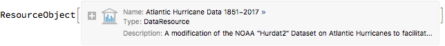 |
Retrieve the default content:
| Out[2]= |  |
What are the most popular Atlantic hurricane names?
| Out[3]= | 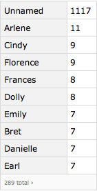 |
A date histogram showing the times of year at which there are Atlantic hurricanes.
| Out[4]= | 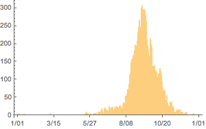 |
When do Atlantic hurricanes make landfall?
| Out[5]= | 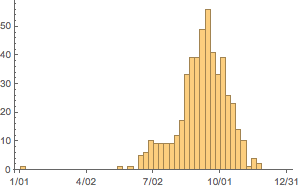 |
The relationship between wind speed and pressure (log scaled), but with metric data.
| Out[6]= | 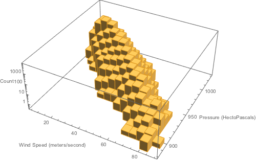 |
Trajectory of Hurricane Katrina from 2005 with windspeed determining the area of the circle.
| Out[7]= | 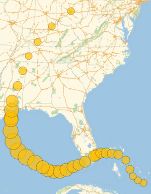 |
The distance of the center of Hurricane Harvey from Houston, Texas, but using miles rather than nautical miles.
| Out[8]= | 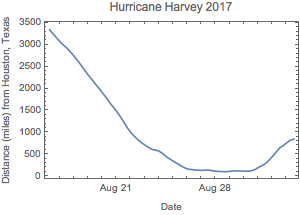 |
Location of all landfalls of Category 3 (or higher) hurricanes.
| Out[9]= | 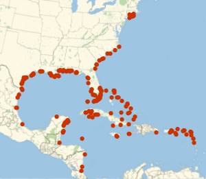 |
Same data but shown as GeoHistogram. The Florida keys, the Mississippi-Louisiana border and the northeast tip of the Yucatan Peninsula look most vulnerable.
| Out[10]= | 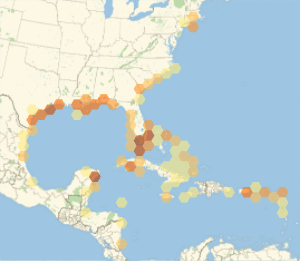 |
Visualize Hurricane Sandy's windfields. (The largest of any Atlantic Hurricane).
| Out[11]= | 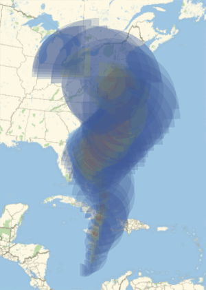 |
Construct a sequence predictor for making "random tropical cyclones" using sequences of wind and pressure (quantized to fall within 20 mile per hour bins and 20 millibar bins). The "trick" for doing this using the built-in SequencePredict function is to quantize the wind and pressures of the storm into a small "alphabet" and then develop a Markov Chain that shows transitions between the "letters" of this "alphabet."
| Out[15]= | 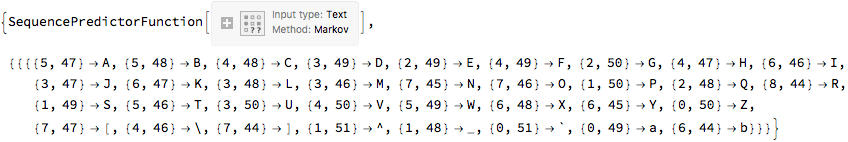 |
Create the start to a tropical storm using wind and pressure. And now generate 1000 next states of the storm to develop a smoothed three dimensional histogram of the wind and pressure six hours later.
| Out[17]= | 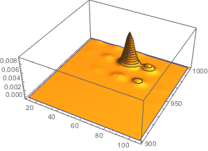 |
A geographic histogram of the location of tropical storms by month of the year (May through November shown). The output could be converted into a movie, although one might want to group by week of year rather than month to create more frames for the animation.
| Out[18]= | 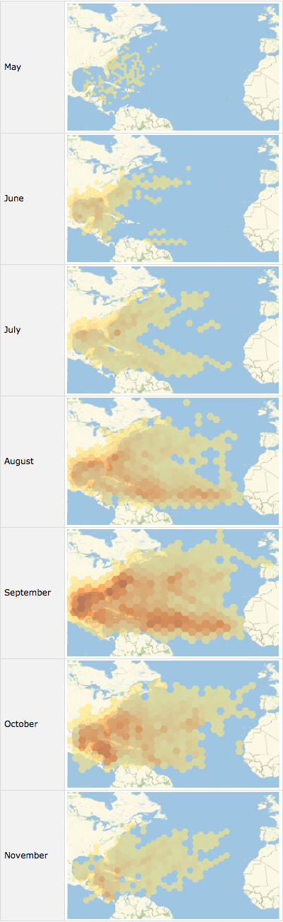 |
![Query[Select[#Status === "Hurricane" && #Event ===
"Landfall" &] /* (DateHistogram[#, "Week",
DateReduction -> "Year", ImageSize -> 300] &), #DateTime &][
ResourceData["Atlantic Hurricane Data 1851-2017"]]](images/51e/51e79752-b35d-4b10-b0d0-9cd44cabb8a9-io-5-i.en.gif)
![Query[Query[
DeleteMissing[#, 1, 2] &] /* (Histogram3D[#,
AxesLabel -> {"Wind Speed (meters/second)",
"Pressure (HectoPascals)", "Count"},
ScalingFunctions -> "Log",
ImageSize -> 500] &), {#Wind, #Pressure} &][
ResourceData["Atlantic Hurricane Data 1851-2017",
"Metric"]](*The nested Query is to alter the default order of \
operations*)](images/51e/51e79752-b35d-4b10-b0d0-9cd44cabb8a9-io-6-i.en.gif)
![Query[Select[#Name === "Katrina" && #DateTime >
DateObject[{2004, 1, 1}] &] /* (GeoBubbleChart[#,
BubbleScale -> "Area", ImageSize -> 300] &),
Thread[Rule[#GeoCoordinates, #Wind]] &][
ResourceData["Atlantic Hurricane Data 1851-2017"]]](images/51e/51e79752-b35d-4b10-b0d0-9cd44cabb8a9-io-7-i.en.gif)
![Query[Select[#Name === "Harvey" && #DateTime >
DateObject[{2017, 1, 1}] &] /* (DateListPlot[#,
PlotLabel -> "Hurricane Harvey 2017",
FrameLabel -> {"Date", "Distance (miles) from Houston, Texas"},
ImageSize -> 300] &), {#DateTime,
GeoDistance[
Entity["City", {"Houston", "Texas", "UnitedStates"}][
"Coordinates"], #GeoCoordinates, UnitSystem -> "Imperial"]} &][
ResourceData["Atlantic Hurricane Data 1851-2017", "Miles"]]](images/51e/51e79752-b35d-4b10-b0d0-9cd44cabb8a9-io-8-i.en.gif)
![Query[Select[#Event === "Landfall" && #Status ===
"Hurricane" && #Wind >=
Quantity[96, "Knots"] &] /* (GeoHistogram[#(*,{"Total",80}*),
ImageSize -> 300] &), #GeoCoordinates &][
ResourceData["Atlantic Hurricane Data 1851-2017"]]](images/51e/51e79752-b35d-4b10-b0d0-9cd44cabb8a9-io-10-i.en.gif)
![Query[Select[#Name === "Sandy" && #DateTime >
DateObject[{2012, 1, 1}] &] /* (GeoGraphics[#,
ImageSize -> 300] &), {ColorData["DarkRainbow"][
0], #Primitives34, ColorData["DarkRainbow"][0.5], #Primitives50,
ColorData["DarkRainbow"][1], #Primitives64} &][
ResourceData["Atlantic Hurricane Data 1851-2017"]]](images/51e/51e79752-b35d-4b10-b0d0-9cd44cabb8a9-io-11-i.en.gif)
![quantizer = Floor[#/20] &;
unquantizer = 20*# &;
characterOfInteger = CharacterRange["A", "z"][[#]] &;
{sp, mapper} = Reap[Module[{sequences, mapping, stringSequences},
sequences =
Normal@Query[
Select[Not[MissingQ[#Wind]] && Not[MissingQ[#Pressure]] &] /*
GroupBy[#ATCF &] /* Select[Length[#] > 3 &] /* Values,
All, ({QuantityMagnitude@#Wind,
QuantityMagnitude@#Pressure} &) /* ({quantizer[#[[1]]],
quantizer[#[[2]]]} &)][
ResourceData["Atlantic Hurricane Data 1851-2017"]];
mapping =
MapIndexed[#1 -> characterOfInteger[#2[[1]]] &,
DeleteDuplicates@Flatten[sequences, 1]];
Sow[mapping];
stringSequences = StringJoin @@@ (sequences /. mapping);
SequencePredict[stringSequences,
FeatureExtractor -> "SegmentedCharacters"]
]
]](images/51e/51e79752-b35d-4b10-b0d0-9cd44cabb8a9-io-12-i.en.gif)
![stormStart = {{57, 1003}, {62, 990}, {73, 986}};
SmoothHistogram3D[
With[{seq =
StringJoin @@
Flatten[Map[
With[{wind = #[[1]], pressure = #[[2]]}, {quantizer[wind],
quantizer[pressure]}] &, stormStart] /. mapper[[1, 1]]]},
Table[unquantizer[(sp[seq, "RandomNextElement"]) /. (Reverse /@
mapper[[1, 1]])], 1000]
], ImageSize -> 300
]](images/51e/51e79752-b35d-4b10-b0d0-9cd44cabb8a9-io-16-i.en.gif)
![Query[Select[#Status === "Tropical Storm" &] /* (GroupBy[
DateValue[#DateTime, "MonthName"] &]) /*
KeyTake[{"May", "June", "July", "August", "September", "October",
"November"}],
GeoHistogram[#, "Hexagon", #2/120 &, ColorFunctionScaling -> False,
GeoRange -> {{0, 60}, {-100, 0}},
ImageSize -> 300] &, #GeoCoordinates &][
ResourceData["Atlantic Hurricane Data 1851-2017"]]](images/51e/51e79752-b35d-4b10-b0d0-9cd44cabb8a9-io-18-i.en.gif)