Wolfram Data Repository
Immediate Computable Access to Curated Contributed Data
Solid Waste Landfill Facilities: US Territories
Originator: Oak Ridge National Laboratory
During emergency response and recovery events, significant amounts of debris must be removed from impacted areas in order to facilitate access to these locations, begin the restoration process, and start the reconstruction of damaged and/or destroyed buildings in the impact zones. This dataset was developed in an attempt to locate Solid Waste facilities, to which debris can be directed. This layer was initiated, based on NAICS and SIC codes, by extracting landfills from the EPA Facility Registry System (FRS) contained in HSIP Gold 2012. This collection is being supplemented, edited, and amended by source data from individual states. Initial and previous collection efforts were limited to landfills that accept Municipal Solid Waste and/or Construction and Demolition Debris, but some of the features from the initial collection were found to have been misclassified; these have been adjusted accordingly (namely, a single C&D type versus Industrial waste facilities). This collection effort focused on expanding the Type domain to include Transfer Station Facilities. All new solid waste features must be considered active facilities based on state source data or state permit at the time of release. Already-existing solid waste features that have become inactive or closed since the initial release are noted as such. This dataset is not intended to be a comprehensive inventory of all permitted solid waste facilities. Specifically excluded from this collection are facilities that accept hazardous or industrial and/or specialty waste types, with some exceptions.The dataset was developed to provide locations of active permitted Solid Waste Landfill facilities (Municipal Solid Waste or Construction and Demolition Debris) and Waste Transfer Stations for the Homeland Infrastructure Foundation-Level Data (HIFLD) database (https://gii.dhs.gov/HIFLD).
(30 columns, 6717 rows)
Retrieve the ResourceObject:
| In[1]:= |
| Out[1]= |  |
View the data:
| In[2]:= |
| Out[2]= |  |
Plot the locations of landfills in Ohio:
| In[3]:= | ![GeoListPlot[
Select[ResourceData[
"Solid Waste Landfill Facilities"], #State == Entity["AdministrativeDivision", {"Ohio", "UnitedStates"}] &][
All, #GeoPosition &]]](https://www.wolframcloud.com/obj/resourcesystem/images/7bb/7bbdc1cc-4d64-4d6c-9dfa-eebdb24072b2/3b6f40da4571cacd.png) |
| Out[3]= | 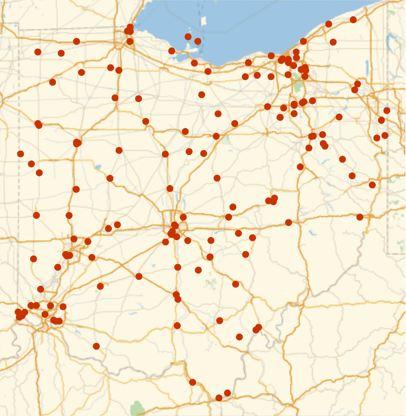 |
Wolfram Research, "Solid Waste Landfill Facilities" from the Wolfram Data Repository (2017) https://doi.org/10.24097/wolfram.18799.data
None (Public Use). Users are advised to read the data set's metadata thoroughly to understand appropriate use and data limitations.