US City Trees 2022

Source Notebook

A dataset of 5 million city trees from 63 US cities: species, location, nativity status, health, and more

Details

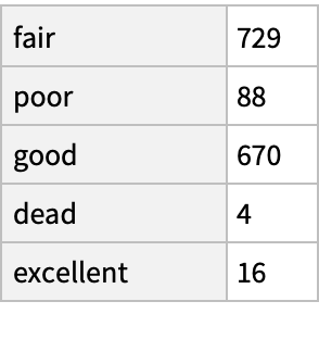
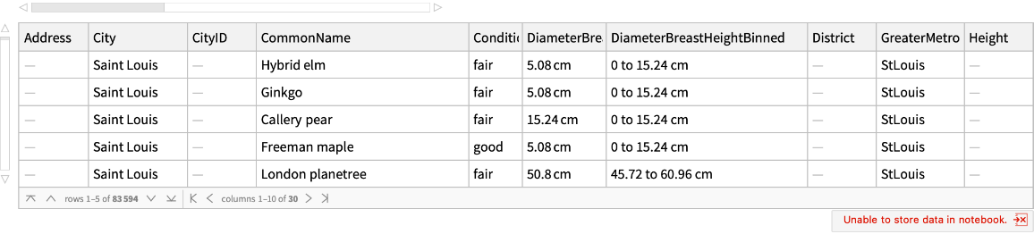
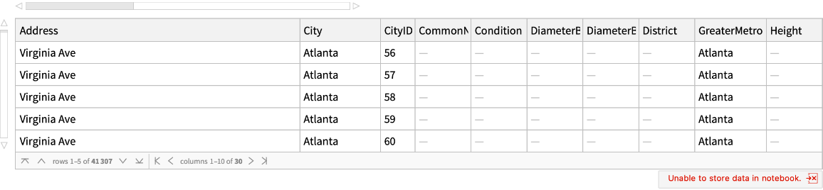
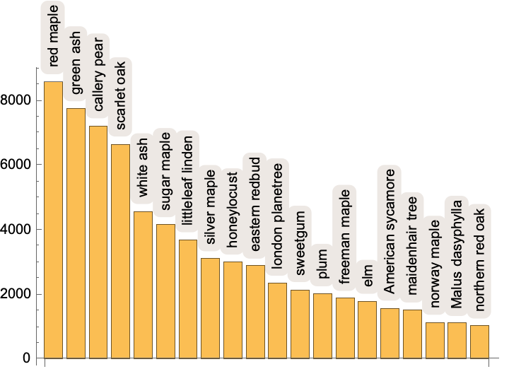
Abstract: Sustainable cities depend on urban forests. City trees -- a pillar of urban forests -- improve our health, clean the air, store CO2, and cool local temperatures. Comparatively less is known about urban forests as ecosystems, particularly their spatial composition, nativity statuses, biodiversity, and tree health. Here, we assembled and standardized a new dataset of N=5,660,237 trees from 63 of the largest US cities. The data comes from tree inventories conducted at the level of cities and/or neighborhoods. Each data sheet includes detailed information on tree location, species, nativity status (whether a tree species is naturally occurring or introduced), health, size, whether it is in a park or urban area, and more (comprising 28 standardized columns per datasheet). This dataset could be analyzed in combination with citizen-science datasets on bird, insect, or plant biodiversity; social and demographic data; or data on the physical environment. Urban forests offer a rare opportunity to intentionally design biodiverse, heterogenous, rich ecosystems.

(63 elements)

Examples

Basic Examples (2) 

Find locations of trees in St. Louis, MO:

In[1]:=
ResourceData[\!\(\*
TagBox["\"\<US City Trees 2022\>\"",
#& ,
BoxID -> "ResourceTag-US City Trees 2022-Input",
AutoDelete->True]\), "Saint Louis"]
Out[1]=

Find locations of trees in Atlanta, GA:

In[2]:=
ResourceData[\!\(\*
TagBox["\"\<US City Trees 2022\>\"",
#& ,
BoxID -> "ResourceTag-US City Trees 2022-Input",
AutoDelete->True]\), "Atlanta"]
Out[2]=

Scope & Additional Elements (1) 

See all available elements:

In[3]:=
ResourceData[\!\(\*
TagBox["\"\<US City Trees 2022\>\"",
#& ,
BoxID -> "ResourceTag-US City Trees 2022-Input",
AutoDelete->True]\)]
Out[3]=

Visualizations (8) 

Retrieve tree data for St. Louis, MO:

In[4]:=
stltrees = ResourceData[\!\(\*
TagBox["\"\<US City Trees 2022\>\"",
#& ,
BoxID -> "ResourceTag-US City Trees 2022-Input",
AutoDelete->True]\), "Saint Louis"];
Length[stltrees]
Out[5]=

Create a histogram of tree diameters in centimeters:

In[6]:=
stltrees[Histogram@*DeleteMissing, "DiameterBreastHeight"]
Out[6]=

Find the most common types of trees:

In[7]:=
BarChart[
 stltrees[TakeLargest[20]@*Counts@*DeleteMissing, "TreeEntity"], ChartLabels -> Placed[Automatic, Above, Rotate[#, Pi/2] &]]
Out[7]=

Retrieve the geopositions of all the trees:

In[8]:=
locations = Normal@stltrees[DeleteMissing, "Location"];

Some of the recorded trees are not in St. Louis, filter those entries out (this takes a long time):

In[9]:=
box = Rectangle @@ GeoBoundingBox[
     Entity["City", {"SaintLouis", "Missouri", "UnitedStates"}][
      "Polygon"]][[All, 1]];
AbsoluteTiming[
 citylocations = Select[locations, RegionMember[box, First@#] &];]
Out[10]=
In[11]:=
Length /@ {locations, citylocations}
Out[11]=

Show each tree on a map (this takes a long time):

In[12]:=
GeoListPlot[DeleteDuplicates@citylocations, PlotMarkers -> {Automatic, Scaled[0.015]}]
Out[12]=

Find just the ginkos:

In[13]:=
stlginkos = Select[stltrees, #["TreeEntity"] === Entity["Plant", "Species:GinkgoBiloba"] &];
Length[stlginkos]
Out[14]=

See the condition of the ginkos:

In[15]:=
stlginkos[Counts, "Condition"]
Out[15]=

Bob, "US City Trees 2022" from the Wolfram Data Repository (2022)  

Data Resource History

Source Metadata

See Also

Publisher Information